The natural topography of Oakville, shaped by its location along the Lake Ontario shoreline and the deep ravines of Sixteen Mile and Bronte Creeks, presents a unique set of geotechnical challenges. As the town has expanded from its historic lakeside core into the more elevated terrain of northern Oakville, cutting into the Halton Till and the underlying Queenston Shale has become routine for new subdivisions. These cuts, while necessary for grading, can trigger instability if the geological history is not properly understood. A rigorous slope stability analysis, grounded in the specific stratigraphy of the region, is the only way to confirm that a proposed slope will remain serviceable through freeze-thaw cycles and heavy spring rainfall. Our work in local neighborhoods like Glen Abbey and Joshua Creek, where we often combine deep excavation monitoring with stability models, has demonstrated that the weathered shale zones control the failure surface geometry in most local cases.
In Oakville's Halton Till over Queenston Shale, a difference of just 2 degrees in the residual friction angle along bedding planes can shift the calculated factor of safety from 1.5 to below 1.0.
Methodology and scope
Local considerations
A 14-unit townhouse development on a ravine lot near Morrison Creek encountered a textbook progressive failure during excavation in April 2022. The contractor cut a temporary 7-meter-high slope at 1H:1V into the weathered shale, assuming the intact rock would stand unsupported through the summer. Two weeks of steady rain filled the tension cracks that had opened at the crest, and a translational block slide moved approximately 50 cubic meters of material into the foundation zone. The slide surface daylighted exactly at the top of the unweathered shale, confirming that the residual strength along the bedding planes — not the intact rock mass — governed the stability. Our remediation design involved regrading the slope to 2.5H:1V, installing a drainage blanket at the shale contact, and constructing a gravity retaining wall at the toe. The lesson is consistent across Oakville's shale ravines: temporary cuts need the same level of hydrogeological scrutiny as permanent slopes.
Applicable standards
NBCC 2015 (Division B, Section 4.2.4 - Slope Stability), CSA A23.3-14 (Design of Concrete Structures, for retaining elements), ASTM D1586-18 (Standard Penetration Test), ASTM D3080-11 (Direct Shear Test for drained strength), MNRF/Oakville Conservation Authority guidelines for valley and stream corridor development
Associated technical services
Limit-Equilibrium Slope Modeling
Two-dimensional analysis using Spencer, Morgenstern-Price, and Bishop methods in Slide2 and SLOPE/W. We model multiple failure geometries, including non-circular block slides along shale bedding planes.
Subsurface Investigation and Instrumentation
Rotary coring and SPT boreholes with installation of vibrating-wire piezometers and slope inclinometers. Continuous monitoring captures the seasonal rise in perched groundwater that triggers most local slope movements.
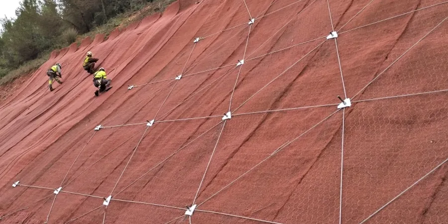
Remedial Design and Construction Review
Design of regraded slopes, drainage systems, and toe buttresses or retaining structures. We provide full-time construction review during excavation to confirm that actual ground conditions match the design assumptions.
Typical parameters
Frequently asked questions
How much does a slope stability analysis for a single-family lot in Oakville cost?
For a standard lot in Oakville requiring two boreholes, piezometer installation, and limit-equilibrium modeling, the cost typically ranges from CA$1,730 to CA$5,300. The final figure depends on access constraints, the height of the slope, and whether the conservation authority requires additional seasonal monitoring data.
What triggers a mandatory slope stability study in Oakville?
Conservation Halton and the Town of Oakville require a geotechnical slope stability assessment for any development within the regulated area of a valley or stream corridor, or for any proposed grading that creates or modifies a slope steeper than 3H:1V and higher than 3 meters. The trigger also applies when a building is located within a distance equal to the height of the slope from the top of bank.
How do you account for the Queenston Shale bedding planes in the model?
The shale in Oakville typically dips southward at 2 to 5 degrees, which can be unfavorable when the slope face is oriented parallel to the lake. We explicitly model the bedding as a weak layer with fully softened residual strength parameters — usually a friction angle of 12 to 18 degrees and zero cohesion — and run a block search algorithm to identify the critical translational failure surface. This approach consistently matches the geometry of observed slope failures in the region.