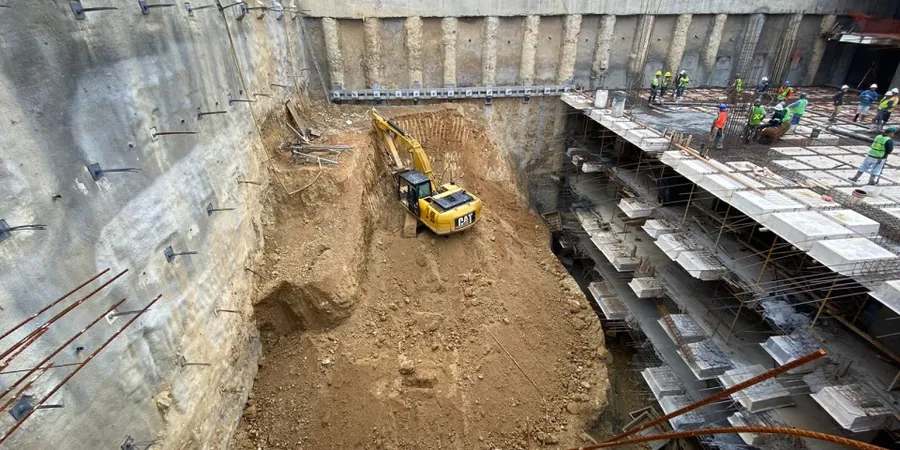
In Oakville, the transition from the Niagara Escarpment's weathered shale to the thick Halton Till plains creates a complex theatre for any excavation deeper than 4.5 meters. The local till is a dense, overconsolidated silty clay with cobbles and boulders—anyone who has tried to drive sheet piles through it near the Trafalgar Road corridor knows it does not behave like textbook soil. The design of a shoring system here must account for high lateral earth pressures that fluctuate seasonally as the water table rises within the till's fissures. Integrating in-situ permeability testing early in the investigation phase often reveals perched water zones that standard borehole logs miss, a detail that can completely alter the dewatering strategy. Our approach anchors every calculation in the specific stratigraphy of southern Ontario, ensuring that temporary bracing and tieback anchors are sized not for a generic soil, but for the exact till unit encountered at 447 metres above sea level.
Designing a shoring wall in Oakville's Halton Till without accounting for perched groundwater is a calculation that looks perfect on paper but fails in the field.
Methodology and scope
Local considerations
The most common and costly mistake in Oakville is treating the excavation design as a temporary afterthought, with a contractor assuming a 1H:1V cut will stand in the till for the duration of a wet spring. When the fissured till becomes saturated, the negative pore pressures that provide apparent cohesion dissipate, and the result is a sudden sloughing failure along the excavation face. This is particularly dangerous adjacent to roads like Speers Road, where traffic vibration accelerates the loss of suction. A proper geotechnical design must model the drained and undrained conditions separately, following the limit states outlined in CSA A23.3 for the structural concrete elements of the shoring. Ignoring the long-term relaxation of earth pressures on tieback anchors can also lead to progressive outward movement, cracking sidewalks and damaging buried utilities that run parallel to the excavation perimeter.
Applicable standards
NBCC 2015 (Division B, Part 4), CSA A23.3:14 (Design of Concrete Structures), ASTM D1586-18 (Standard Penetration Test), FHWA-RD-97-130 (Design of Deep Excavations in Urban Environments), MTO Geotechnical Design Manual (for relevant loading)
Associated technical services
Shoring Wall Design and Analysis
Full structural and geotechnical design of soldier pile and lagging, secant pile, or sheet pile walls. We perform beam-on-elastic-foundation analysis using WALLAP or Rocscience RS2, incorporating staged excavation sequences and pre-loading of tieback anchors to limit lateral deflection to less than 0.5% of the excavation height, as required for sensitive adjacent structures.
Dewatering and Groundwater Control Plans
Design of deep well, eductor, or vacuum-assisted dewatering systems tailored to the low-permeability Halton Till and underlying silt layers. Our plans include detailed groundwater flow modeling using MODFLOW to predict drawdown radii and assess settlement risks to neighbouring properties within the Town of Oakville's permit requirements.
Typical parameters
Frequently asked questions
What is the typical cost range for a geotechnical design of a deep excavation in Oakville?
For a complete design package, including soil-structure interaction analysis, shoring wall structural calculations, and a dewatering plan, fees generally range from CA$2,990 for a straightforward single-family lot excavation to CA$11,460 for a complex multi-level commercial basement in the downtown core. The final cost depends on the wall type, the number of tieback levels, and the extent of instrumentation specified in the monitoring plan.
How does the Halton Till affect the choice of shoring system?
The till's overconsolidated nature means it can stand vertically for short periods, but its fissured fabric allows water ingress that rapidly reduces strength. This dictates a solid system like soldier piles with heavy timber lagging or secant piles, rather than lighter interlocking sheet piles which can be difficult to install without pre-drilling due to the abundant cobbles and boulders.
What monitoring is required during excavation work in Oakville?
As a minimum, we specify inclinometers on the shoring wall, optical survey points on adjacent roadways and buildings, and vibrating wire piezometers to track pore pressure changes. For excavations deeper than 6 meters near heritage properties, real-time automated total stations are often mandated to meet the Town's risk management guidelines.
Can the excavated shale bedrock be reused as fill on site?
Queenston Formation shale is notorious for its durability issues. Once excavated, it slakes into small chips and clay when exposed to wet-dry cycles. While it can sometimes be used as structural fill if properly compacted and sealed immediately, it generally fails the Ontario Ministry of Transportation's micro-Deval abrasion requirements, making it unsuitable for granular base courses without significant processing.