Oakville sits on a complex glacial stratigraphy that shifts dramatically within half a kilometer — dense Halton Till on the higher ground near Dundas Street, and softer glaciolacustrine silts closer to Lake Ontario. This patchwork is exactly why the NBCC 2020 seismic provisions matter here. A generic site class assumption can misrepresent the actual ground response. The MASW survey cuts through that uncertainty with a direct, non-invasive measurement of Vs30, giving engineers a defensible site class without relying on proxy correlations. We run the survey with a 24-channel setup and 4.5 Hz geophones, following ASTM D4428/D4428M, and process the dispersion curves with care rather than rushing the inversion. In neighborhoods like Bronte or Clearview where weathered Queenston shale is shallow, the shear wave profile often reveals a velocity inversion that standard borehole-based methods would miss. We often pair the MASW with targeted seismic refraction when the bedrock depth is uncertain, and with CPT soundings for a continuous stratigraphic log in the silty zones near the creeks.
A reliable Vs30 measurement replaces assumptions with data, and in Oakville's variable glacial deposits that can shift the site class from C to D — altering the design spectrum significantly.
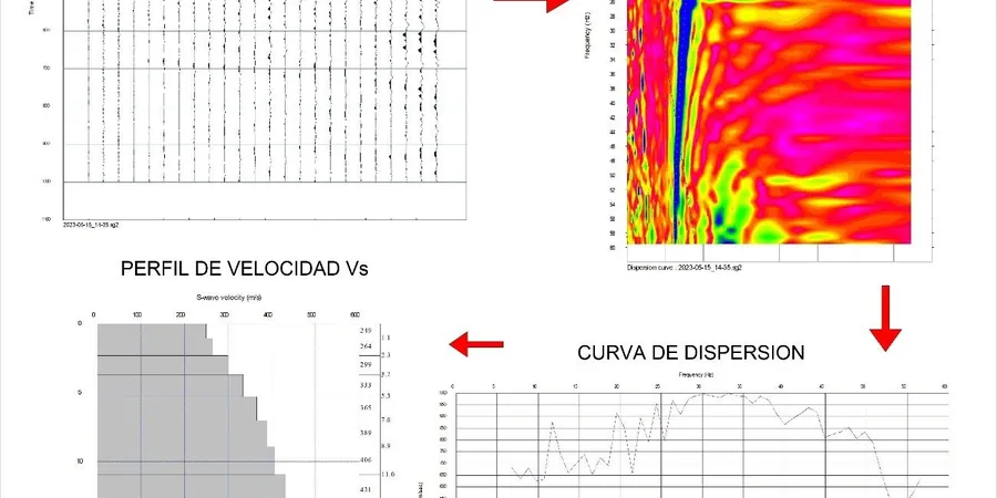
Methodology and scope
Local considerations
Two sites in Oakville, separated by less than a kilometre, can fall into different NBCC site classes. The strip along Lakeshore Road, with its thick saturated silts and sand lenses, frequently yields Vs30 values in the 180–240 m/s range — Site Class D or even E in places. Move north to Upper Middle Road and the dense Halton Till pushes velocities above 360 m/s, firmly in Site Class C, sometimes B where the shale is within five metres of grade. The cost of getting this wrong is not trivial: a Site Class D spectrum can be 20–30% higher in short-period acceleration than Class C. If the design assumes Class C but the true condition is Class D, the structure is under-designed. If the assumption is Class D and the site is actually Class C, the owner pays for unnecessary seismic demand. The creeks — Fourteen Mile, Sixteen Mile, Bronte — have carved valleys with steep velocity contrasts on their flanks. A single MASW line at the building pad is sufficient for uniform sites, but on sloping terrain or near creek banks we recommend two orthogonal spreads to check for lateral variability.
Applicable standards
NBCC 2020 — National Building Code of Canada, seismic provisions, ASTM D4428/D4428M — Standard Test Methods for Crosshole Seismic Testing (referenced for MASW), CAN/CSA A23.3 — Design of concrete structures, seismic requirements, Eurocode 8 Part 1 (EN 1998-1) — referenced for international projects
Associated technical services
Standard Vs30 Site Classification
A single 24-channel MASW line positioned at the building footprint, processed to extract Vs30 and NBCC site class. Includes 1D shear wave velocity profile, dispersion curves, and a signed engineering report. Suitable for low- and mid-rise residential, commercial infill, and additions where the site is relatively flat and geology is known from regional mapping.
Multi-Line MASW with Cross-Section
Two or three intersecting MASW spreads for irregular sites, sloping ground, or projects where the foundation grade varies by more than 1.5 metres across the footprint. We produce a 2D Vs cross-section interpolated from the individual 1D profiles, identify velocity anomalies, and deliver a site class map rather than a single value. Used for schools, mid-rise condominiums, and industrial buildings near the QEW corridor.
Typical parameters
Frequently asked questions
What does a MASW survey cost in Oakville?
Budget between CA$2,290 and CA$3,690 for a standard single-line MASW survey with Vs30 classification and a signed report. Multi-line surveys or sites requiring traffic control along Lakeshore or Dundas will push toward the upper end. The quote includes mobilization within Halton, the field work, dispersion processing, inversion, and the engineering deliverable.
How long does field work take on a typical Oakville lot?
One to two hours for a single spread on a residential lot. We need about 50 metres of clear ground for the geophone array. If the site is tight — common in the older neighborhoods south of the QEW — we can use a staggered array or shorter spread, but that reduces the maximum depth of investigation slightly.
Can MASW replace a borehole for site classification?
For NBCC site class determination, yes — the code accepts Vs30 from surface-wave methods. What MASW does not provide is a physical sample of the soil for laboratory testing. If you need strength parameters or consolidation data, a borehole or SPT drilling is still required. The ideal approach is a single borehole for material characterization plus MASW for the velocity profile.
Is MASW reliable on the shale bedrock in north Oakville?
It is, with one caveat. The Queenston shale creates a strong velocity contrast that can limit the penetration depth of the fundamental Rayleigh mode. We address this by including higher-mode dispersion in the inversion and, when feasible, extending the array to 69 metres. In practice, we have successfully resolved the shale interface and measured Vs30 values above 400 m/s in the Glen Abbey and Palermo areas.